The 2026 event has ended. This map will be updated once 2027 details are announced.Next: Tsuchiura All Japan Fireworks Competition (Sat, November 7) →
Event Details
- Date & time
- Sat, August 1, 2026 19:00〜20:30
- Venue
- Arakawa riverbed (Itabashi side, upstream of Toda-bashi Bridge), Itabashi ward, Tokyo
- Fireworks count
- approx. 15,000 shells
- Organizer
- Itabashi Fireworks Festival Executive Committee(Official site)
Maps keep updating. Previously viewed maps work with a weak signal.
FAQ
Where are the fireworks launched?
On the Arakawa riverbed (Itabashi side, upstream of Toda-bashi Bridge). The Toda-bashi Fireworks Festival is held simultaneously across the river, so fireworks rise from both banks.
What time does it start and end?
7:00–8:30 PM.
Is it cancelled if it rains?
Cancelled in severe weather. The decision is announced on the official website on the day.
Are there less-crowded viewing spots?
Riverbanks slightly up- or downstream are relatively open. Free viewing areas are shown on the map.
Which stations are closest?
About a 20-minute walk from Takashimadaira, Nishidai, Hasune, or Ukima-Funado stations. Takashimadaira is closest to the free viewing area.
Is there a free viewing area?
Yes. A free viewing area with no ticket required is set up on the Arakawa riverbed, about a 20-minute walk from Takashimadaira Station. Its extent is shown on the "Viewing Area" layer of the map.
Is paid seating available?
Yes, via the official website. The paid seating area is closest to Hasune and Ukima-Funado stations; its location is shown on the "Paid Seating" layer of the map.
Can I send my saved spot or a meeting point to friends?
Yes. Long-press the map to mark a meeting point, attach up to 3 photos of nearby landmarks, and send the link. Recipients need no app: the spot and photos open in the browser on the event map, with viewing areas and road closures.
Send a meeting point
- Long-press the map to mark where to meet.
- Tap the camera to add up to 3 photos of nearby landmarks. Photos are compressed automatically.
- Send the link. Friends see the spot on the event map, with road closures and nearest stations. No app needed.
Itabashi Fireworks Festival: Launch Site, Viewing Areas & Nearest Stations
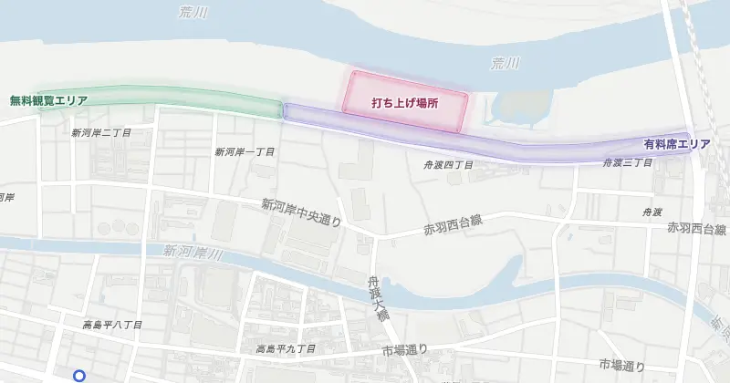
Areas and positions are approximate, based on the official venue and traffic maps. On the day, follow on-site signs and restrictions.
Launch site
- Launch site打ち上げ場所
Fireworks launch site on the Arakawa riverbed. The surrounding area is off-limits.
Viewing area
- Free viewing area無料観覧エリア
Free viewing area; no ticket required. Nearest station is Takashimadaira (about a 20-minute walk).
Paid seating
- Paid seating area有料席エリア
Paid viewing area; a ticket is required. Nearest stations are Hasune and Ukima-Funado.
Station
- Takashimadaira Station高島平駅
Toei Mita Line. Nearest station to the free viewing area. About a 20-minute walk.
- Nishidai Station西台駅
Toei Mita Line. About a 20-minute walk to the venue.
- Hasune Station蓮根駅
Toei Mita Line. Hasune and Ukima-Funado stations are convenient for the paid seating area. About a 20-minute walk.
- Ukima-Funado Station浮間舟渡駅
JR Saikyo Line. Nearest station to the paid seating area. The free viewing area is over a 90-minute walk away; use Takashimadaira Station instead.
More events
- Roppongi Illuminations Map 2026Thu, November 5, 2026
- Tsuchiura All Japan Fireworks Competition Map 2026Sat, November 7, 2026
- Narita Fireworks in Imbanuma Map 2026Sat, November 7, 2026
- Asakusa Tori-no-Ichi Map 2026Sat, November 7, 2026
- Yoyogi Park Events Map 2026Sat, November 7, 2026
- Atami Fireworks Festival Map 2026Sun, November 8, 2026
- Setagaya 246 Half Marathon Map 2026Sun, November 8, 2026
- Marunouchi Illumination Map 2026Thu, November 12, 2026
- Kawaguchi Fireworks Festival Map 2026Sat, November 14, 2026
- Ebina Citizens' Festival Fireworks Map 2026Sun, November 15, 2026
- Tsukuba Marathon Map 2026Sun, November 22, 2026
- Chichibu Night Festival Map 2026Wed, December 2, 2026
- Shonan International Marathon Map 2026Sun, December 6, 2026
- Hyakuri Air Show Map 2026Sun, December 6, 2026
- Setagaya Boro-ichi Map 2026Tue, December 15, 2026
- Comic Market 109 Map 2026Tue, December 29, 2026
- Kawasaki Daishi Hatsumode Map 2027Thu, December 31, 2026
- Naritasan Hatsumode Map 2027Thu, December 31, 2026
- Meiji Jingu Hatsumode Map 2027Fri, January 1, 2027
- Hakone Ekiden Map 2027Sat, January 2, 2027
- New Year Greeting Map 2027Sat, January 2, 2027
- Shinjuku City Half Marathon Map 2027Sun, January 31, 2027
- Tokyo Marathon Map 2027Sun, March 7, 2027
- Sumida River Fireworks Festival Map 2026Ended
- Katsushika Fireworks Festival Map 2026Ended
- Jingu Gaien Fireworks Festival Map 2026Ended
- Chofu Fireworks Map 2026Ended
- Kita City Fireworks Map 2026Ended
- Setagaya Tamagawa Fireworks Festival Map 2026Ended
- Kawasaki Tamagawa Fireworks Festival Map 2026Ended
- Konosu Fireworks Festival Map 2026Ended
- Tokyo Bay Grand Fireworks Festival Map 2026Ended